
In today’s rapidly evolving technological landscape, the need for high-precision positioning systems has never been greater. The BeiDou Navigation Satellite System (BDS) recognizes this demand and is undergoing a significant upgrade to enhance its services. The new services being introduced aim to provide decimeter-level accuracy within minutes, marking a substantial improvement over current capabilities. These advancements are crucial for various sectors such as autonomous driving, robotic navigation, and smart city infrastructures, which rely heavily on accurate and reliable location data for optimal functioning.
While traditional systems like the Global Positioning System (GPS), GLObal NAvigation Satellite System (GLONASS), and Galileo have set high standards in the field of positioning, they still face challenges such as limited regional coverage and long convergence times. This highlights the necessity for enhanced navigation satellite systems that can bridge these gaps and provide reliable services on a global scale.
Research and Development Initiatives
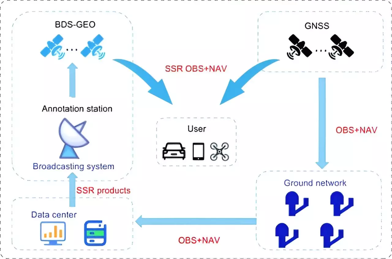
Researchers from esteemed institutions such as the Beijing Institute of Tracking and Telecommunication Technology, the Shanghai Astronomical Observatory, and Wuhan University have been actively involved in studying and improving the BeiDou system. Their recent study published in the journal Satellite Navigation sheds light on the high-precision services offered by BeiDou, detailing its current state, achievements, and future trajectory. The study particularly focuses on the PPP-B2b of BDS-3, which can achieve decimeter-level accuracy within a commendable 14 minutes.
Despite its advancements, BDS-3 still trails behind global counterparts like Galileo and the Quasi-Zenith Satellite System (QZSS) in terms of regional coverage and convergence time. To address these shortcomings, the researchers have proposed a multi-layer development framework that emphasizes the integration of low Earth orbit (LEO) satellites. By incorporating a LEO constellation consisting of 288 satellites, BeiDou can significantly improve its positioning accuracy to better than 5 cm within just a minute, thereby enhancing global coverage and drastically reducing convergence time.
Dr. Xingxing Li from Wuhan University emphasizes the pivotal role that advancements in BeiDou’s high-precision services play in meeting the escalating demands of modern navigation applications. The integration of LEO satellites, in particular, holds immense promise as it enhances coverage and reduces convergence time, bringing us closer to achieving real-time, centimeter-level positioning accuracy on a global scale. The enhanced BeiDou high-precision services have far-reaching implications for various applications such as autonomous driving, unmanned aerial vehicles, and smart device navigation, positioning BeiDou as a leading provider of high-precision services on a global scale.
The upgraded BeiDou Navigation Satellite System heralds a new era of high-precision positioning, paving the way for enhanced services that cater to the evolving needs of a technologically advanced world. The integration of LEO satellites and the commitment to continuous improvement underscore BeiDou’s position as a frontrunner in the realm of high-precision satellite navigation.